This assessment of streets, sidewalks, and other routes connecting the 28 DART rail stations examined infrastructure that will enhance first/last mile accessibility for pedestrians. The study included detailed evaluations of pedestrian infrastructure needs for corridors within a one-half mile radius of the DART facilities, wherein improvements were identified and ranked as High, Medium, and Low, based on the potential benefit to improve active user access to and from the stations. Estimated construction costs, primarily for new sidewalks and pedestrian safety measures such as crosswalks, signals and phasing for implementation, were developed for each station area. The resulting project deliverables and final reports were provided to DART and each city to be referenced during future project development, helping to improve access and connectivity for residents and workers with the key goal to increase transit ridership.
The Opinions of Probable Construction Costs for all stations are identified in the following table:
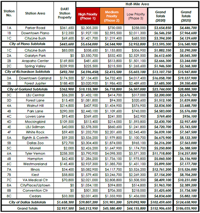
Click on the image for an enlarged view of the costs.
DART - NCTCOG Final Report [PDF 52 MB]
- Appendix A Field Work Dates
- Appendix B Part 1 Data Collection Maps & Forms [PDF 23 MB]
- Appendix B Part 2 Field Data Checklist - Stations [PDF 48 MB]
- Appendix B Part 3 Field Data Checklist - Stations (Cont.) [PDF 47 MB]
- Appendix B Part 4 Field Data Checklist - Stations (Cont.) [PDF 59 MB]
- Appendix C Crosswalk Improvement Evaluation Details
- Appendix D Crosswalk Improvement Selection Tables
- Appendix E Half-Mile Area Improvement Prioritization - Initial Trial Methodology Details
- Appendix F Half-Mile Area Improvement Prioritization - Final Methodology Details [PDF 1.2 MB]
- Appendix G Cost Estimating Details
- Appendix H Estimated Quantities & Opinions of Probable Construction Cost - Station Property Improvements [PDF 1.5 MB]
- Appendix I Half-Mile Area Recommendation Details & Detailed Improvement Mapping [PDF 94 MB]
- Appendix J Half-Mile Improvement Matrices [PDF 8.3 MB]
- Appendix K Estimated Quantities & Opinions of Probable Construction Cost - Half-Mile Improvements [PDF 3.8 MB]
Dallas Final Report [PDF 32 MB]
- Appendix A Field Work Dates
- Appendix B Data Collection Maps & Forms [PDF 72 MB]
- Appendix C Crosswalk Improvement Evaluation Details
- Appendix D Crosswalk Improvement Selection Tables
- Appendix E Half-Mile Area Improvement Prioritization - Initial Trial Methodology Details
- Appendix F Half-Mile Area Improvement Prioritization - Final Methodology Details
- Appendix G Cost Estimating Details
- Appendix H Estimated Quantities & Opinions of Probable Construction Cost - Station Property Improvements
- Appendix I Half-Mile Area Recommendation Details & Detailed Improvement Mapping [PDF 12 MB]
- Appendix J Half-Mile Improvement Matrices [PDF 7 MB]
- Appendix K Estimated Quantities & Opinions of Probable Construction Cost - Half-Mile Improvements [PDF 2 MB]
Garland Final Report [PDF, 24.5 MB]
Plano Final Report [PDF, 33 MB]
Richardson Final Report [PDF, 39 MB]