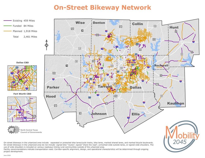
On-Street Bikeways
On-street bikeways facilitate safe and convenient travel for bicyclists, and they serve as extensions of the Regional Veloweb and community shared-use path network by providing non-motorized travel connections between housing, employment, major destinations, and transit facilities. The existing and planned on-street bikeway network, adopted as part of Mobility 2045, provides the densest network of bicycle facilities in a growing number of communities throughout the region. Currently more than 23 locally adopted plans include on-street bikeway facilities representing more than 2,461 miles in various stages of development. Consistent with guidance from AASHTO, the National Association of City Transportation Officials (NACTO), the Federal Highway Administration, and the Separated Bike Lane Planning and Design Guide, the type and design of on-street bikeways can vary based on the community and context in which they are located. Bikeways in urban and suburban areas of the region are recommended to include the following:
- Separated or protected bike lanes/cycle tracks
- Bike lanes
- Marked shared lanes
- Marked bicycle boulevards
Communities also may feature on-street bicycle facilities that include signed bike routes and signed shared roadways without designated bikeway pavement markings, including wide outside lanes. However, these facilities are not represented in Mobility 2045. Bikeways between communities in rural unincorporated areas of the region generally consist of paved shoulders, particularly on roadways with higher speeds or traffic volumes. Paved shoulders in these rural areas provide opportunities for travel between small communities.
Click on a link below to return to the Trails and On-Street Bikeways Network home page, view expanded maps and read more about the 2045 Regional Veloweb, community paths, and detailed county maps.