Risk MAP Discovery - Elm Fork Trinity Watershed
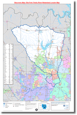
Located in North Texas, the Elm Fork Trinity Watershed is part of the Trinity River Basin. It has been identified by the federal government using a national standard hierarchical system which is based on surface hydrologic features. The Elm Fork is classified as a fourth-level (sub-basin) with a unique 8-digit Hydrologic Unit Code (HUC) - #12030103.
The Elm Fork Watershed covers an area of 1857.7 square miles and crosses into eight (8) counties. These counties include: Collin, Cooke, Dallas, Denton, Grayson, Montague, Tarrant, and Wise. The watershed either totally covers or partially spans across fifty-two (52) cities/towns. The Elm Fork contains about 5% of the State's total population with approximately 1,218,000 residents.
The Elm Fork of the Trinity River is the primary river in the watershed. Each of the four branches (the West Fork, the Clear Fork, the Elm Fork, and the East Fork) of the Trinity begins its journey near the Texas-Oklahoma border near the Red River. The Trinity River completes its journey at Trinity Bay (the northeast portion of Galveston Bay) in Chambers County.
The Elm Fork Discovery Project was completed in 2013, and the final report can be viewed below.
 Elm Fork Trinity Watershed Related Information