|
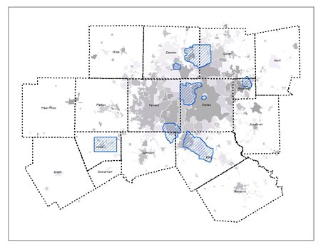
 In 2019, the North Central Texas Council of Governments facilitated the cooperative purchase of 0.5-Meter LiDAR (4PPM) for 540 square miles of the NCTCOG region. The contractor for this project was Woolpert. The LiDAR data were collected in January through March 2019 (leaf-off) and are available for purchase via DFWMaps Marketplace according to the following price schedule. In 2019, the North Central Texas Council of Governments facilitated the cooperative purchase of 0.5-Meter LiDAR (4PPM) for 540 square miles of the NCTCOG region. The contractor for this project was Woolpert. The LiDAR data were collected in January through March 2019 (leaf-off) and are available for purchase via DFWMaps Marketplace according to the following price schedule.
The LiDAR data are sold in 3,000' x 2,000' tiles, or 0.215 square miles. Sample files and a shapefile of the tile structure may be downloaded below.
LiDAR Sample - LAS Format
SDCP Index Grid
Specifications
| Camera |
Optech Galaxy Airborne LiDAR System |
| Nominal Pulse Spacing |
0.5 Meter, 4 points per meter |
| Accuracy |
9.25cm vertical accuracy in non-restricted airspace and 12.5cm vertical accuracy in restricted airspace. |
| Relative Accuracy |
<=6 RMSEz within individual swaths and <=8cm within swath overlap |
| Measurement Rate |
500kHz |
| Returns |
up to 5 |
| Capture |
January-March 2019 |
| Ground Conditions |
Leaf off; free from snow, haze, fog, or dust; streams within normal banks |
| Coordinate System |
Texas State Plane, North Central Zone |
| Horizontal Datum |
NAD 83 |
| Vertical Datum |
NAVD88 |
| Units |
US Survey Feet |
| Breaklines |
Hydrologic flattening |
| Format |
LAS 1.2, classified text file, bare earth DEM, first return DSM |
| Classification |
Data are classified according to ASPRS classification standards with 98% of buildings identified. |
More information on the 2019 project can be found in the project level metadata.
For questions regarding the 2019 LiDAR project, send us an email.
|